
The island of Murter belongs to Šibenik archipelago. It is divided from the coast by a narrow channel. A bridge was built over that channel near Tisno so that nowadays the island is connected to the coast. The continuity of living on the island dates back to prehistoric times. Traces of early Greek presence were also found, for example a recent find of a terracotta female head with emphasized stylistic characteristics. At the site of Gradina, named after a frequent toponyme characteristic of wider east Adriatic space, at the end of the modern town of Murter, prehistoric finds were recorded a long time ago. There is even more evidence of life in the Roman times. Archeological research conducted from 1966 until 1973 revealed the remains of architectural structures at Gradina and in its foothill, by the coast and in the sea shallows. Pliny draws attention to Colentum by mentioning it after the main Liburnian urban center, colonia Jader (Zadar). He places it at the mouth of river Krka (....Collentum insula XVIII, ostium Titii fluminis ...). Ptolemy mentioned it in the Greek transcription (Kollenton) as part of the convent of the near border center Scardona. Its name appeared in some later written sources (I. Lučić, A Fortis et al.).
There is no evidence which would indicate possible urban character of Roman Colentum. It seems that on the slopes of Gradina and by the sea different economic, rural and pier contents were built. It is understandable as it was an important and busy maritime area. Even before the first excavations in 1907-1909, ground level remains of a well preserved object, called ''the dungeon'', were visible. It was a Roman cistern which was filled by rainwater from the roof. Later research revealed the remains of architecture with economic or rural purpose. Available records revealed ten housing objects which were arranged in form of terraces adjusted to the ground configuration. The parts of the architecture can be clearly seen even in the sea, since the sea level arose compared to ancient times. Among the preserved remains a villa with an apse draws particular attention. It stretches along the coast about 50m and the underwater research revealed the remains of a waterfront. The elements of hypocaust, or the suspensures, were also found, which proves that some spaces were heated. The floors of some rooms were decorated with black and white mosaics with characteristic geometric ornaments. A few inscriptions were found, mainly sepulchral, and lots of other objects which served the population that lived in the buildings.
Info: Useful information and links, address book
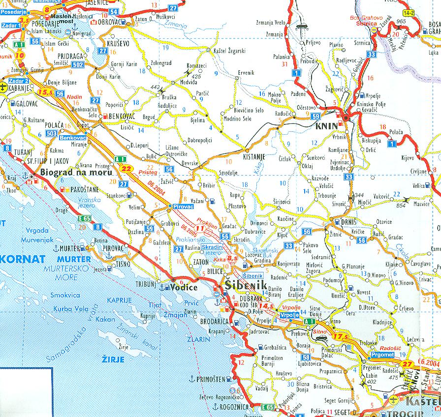
Skradin is a city in Croatia, in Šibenik-Knin County; cca. 4 000 inhabitants; postcode 22222; phone area code 00 385 (0)22.
Skradin (ancient Scardona) is situated on the right bank of the Krka river, at the entrance to the Krka National Park, 17 km from Šibenik. The Krka Waterfalls, the greatest of which is Skradinski buk, are the main touristic attraction of the region. The settlements of the Skradin area are Rupe, Dubravice, Bićine, Bribir, Cicvare, Gorice, Gračac, Ićevo, Krković, Lađevci, Međare, Piramatovci, Plastovo, Skradinsko polje, Skradin, Sonković, Vaćani, Velika Glava, Bratiškovci, Žažvić i Ždrapanj.
The position of Skradin was inhabited since prehistory. The autochthonous Liburnian settlement was developed in the Late Bronze Age as a port in the service of the great Liburnian center Varvaria. Under the Roman rule Scardona became the seat of the judicial convent for the northwestern part of the province of Dalmatia. During the reign of Vespasianus it became a municipium and developed into an important traffic, administrative and military center of the Liburnian and Iapodian area. It became a dioecesan seat, probably in the 6th century.
Scardona was mentioned by ancient and medieval writters such as Pliny the Elder, Strabo, Claudius Ptolemy, Procopius from Caesarea, Constantine Porphyrogenitus and an anonymous geographer from Ravenna. It was also registered on the Peutinger's Map.
During the Migration Period the town was destroyed, and later reinhabited. Ancient name was preserved in croatian form as Skradin. At the end of the 13th century it became one of the seats of the powerful dukes of Bribir from the House of Šubić. Between the year 1522 and 1684 the city was ruled by the Ottoman Turks and after that period, until 1794, by the Venetian Republic. During the time of Napoleon Skradin was a part of the French Empire and later of the Habsburg Monarchy. Its role moved to Šibenik. Pope Leo XII abolished the bishopric of Skradin in the year 1828.
Among the notable persons from Skradin are ottoman statesman Rustem-paša Opuković, an active member of the so-called Croatin National Revival in the 19th centuryJosip Mrkica, and an archaeologist and the founder of the Croatian Association of Archaeologists Fr Lujo Marun OFM.
Šibenik City Museum continues with systematic archaeological research in Skradin since 1977.
Bribir (Varvaria) is a village in Croatia, on the eastern edge of the Ravni Kotari region in the Šibenik-Knin County, 14 km away from Skradin. According to the 2001 census it has 79 inhabitants. Postcode 22222 Skradin; phone area code 00 385 (0)22.
The oldest traces of settlement date to the Neolithic period on the site of Krivače in the fertile field by the riverlet Bribirščica, extending towards the west to the village of Ostrovica. At the junction of the field an d the Bukovica crass plateau, there rises the spacious hill of Bribirska Glavica (altitude 300 m, surface area 72000 m2).
The first traces of human presence belong to the neolithic period: upper neolithic – Impresso culture, middle and lower neolithic – Danilo and Hvar culture. A bigger settlement appeared in the iron age. It developed and spread during the Liburnian dominance and continued as a Liburnian fortified settlement („gradina“) until the arrival of Romans. It was the center of a strong Liburnian community (civitas) of Varvarini, whose territory extended to the east of the Krka River. In the 1st c. BC, during the proconsulate of Julius Caesar, new and strong city walls were built in a combination of homegrown tradition and Roman building techniques, and the settlement acquired the status of municipium - Municipium Varvariae. Varvaria therefore recieved the Italic citizenship (ius Italicum), a city council (ordo decurionum) and other institutions customary to Roman municipia.
During the Migration Period Varvaria saw hard days, and at the time of Avar and Slavic incursions destruction and decay. In the ruins of the ancient city a center of a Croatian medieval county emerged, and the house of its rulers grew into the House of Šubić, Dukes of Bribir. Pre-Roman name known to us through the latinized version Varvaria was modified in the Croatian language into Bribir. A 10th c. Byzantine writer and emperor Constantine Porphyrogenitus mentions the county in its Greek form "Brebera". The greatest flourishing of Bribir occured in the 13th and 14th century at the time of Paul I Šubić of Bribir, Ban of Croatia. The town was 1522/23 possessed by the Ottoman Turks and after their departure the settlement continued only on the foothills of Bribirska Glavica.
Archaological research began in 1908 under the leadership of Fr Lujo Marun OFM, from Skradin, who gave to Bribirska glavica the name of "Croatian Troy", and the research has continued to this day with only short breaks (S. Gunjača, M. Suić, Š. Batović and others). Only a fifth of the area inside the walls has been researched. The EU has been financing archaeological digs, restoration and conservation of the site through the CARDS program.