The eastern border of the Republik of Croatia is partly defined by the river Danube. In Roman times, the Danube acted as the border (limes) between the Roman Empire and barbaric lands almost in its full length.
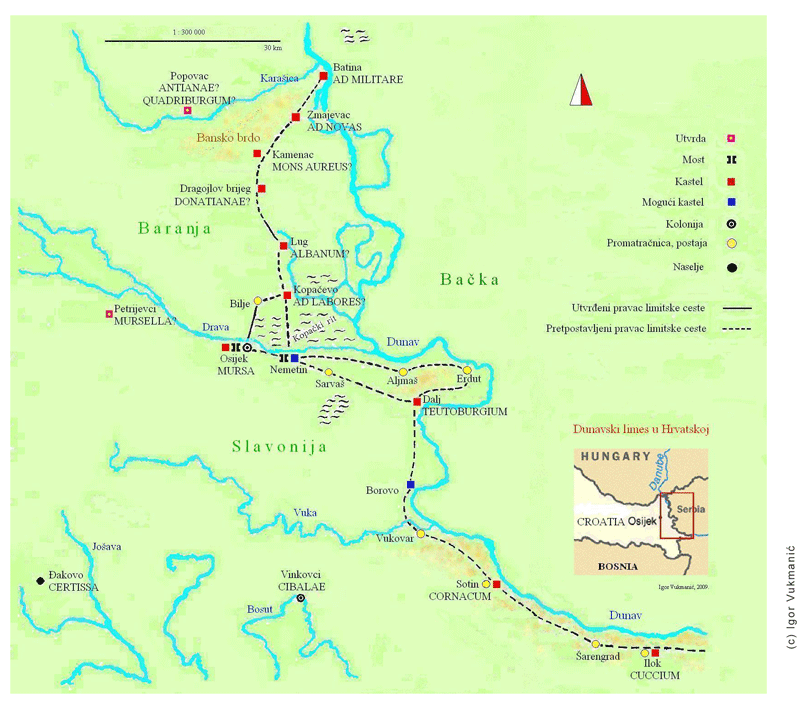
The Croatian part of the Danubian limes stretches from Batina Skela to Ilok and is 188 km long. It goes through two areas that do not have just different names (Baranja and Slavonija) but also different geomorphologic structure. The north-western Baranja is a flat area dominated by the Baranja Hill (243 m), while the area between the rivers Danube and Drava is covered by marshland of Kopački Rit. In Slavonian region the limes is marked by steep and high banks of the Danube. The Croatian part of the Danubian limes can be separated in two areas: the “belt” immediately by the river (one has to bear in mind that the Danube has changed its flow in this area to some extent) and the hinterland. In the hinterland of this part of limes there was a number of local roads, but also three very important land corridors that went along important rivers such as the river Sava (Emona – Siscia – Sirmium) and Drava (Poetovia – Mursa – Cibale – Sirmium), as well as the road that linked Klosterneuburg/Cannabiaca and Zemun/Taurunum, constructed by Romans to increase the flow of army and goods. That road went along the right bank of the Danube. It is an ancient route, known already in prehistory and partly still in use today.
The research has shown that this Roman, so-called military road, moved away from the Danube in two places. South of Batina Skela (Ad militare) it turns towards the southern slopes of the Ban Hill and Zmajevac (Ad Novas). From Zmajevac one road went to Pecs (Sopianae), while the limes road went further towards the south, and passed through the present-day settlements of Dragojlov Brijeg, Grabovac, Lug, Vardarac and Kopačevo. In this section the modern road follows the Roman route. After Kopačevo the road could have turned more to the west towards Bilje from where it went to Osijek (Mursa) or it could have continued straight to the south towards the river Drava crossing near Nemetin (Ad Labores). From there the road went through Sarvaš – Bijelo Brdo to Dalj (Teutoborgium). However, both field surveys and archeological finds suggest yet another possibility. The road could have connected Nemetin – Aljmaš – Erdut – Dalj. From Dalj (Teutoburgium), the road went back to the Danube, along the route Gradac – Borovo – Vukovar – Sotin (Cornacum) – Ilok (Cuccium).
(http://limescroatia.eu/karte/)
 English